Trail Walking Torres del Paine - Glacier GREY  - Photo
 GOHIER
GOHIER

User

© OpenStreetMap contributors
Length
Length
12.9 km
Max alt
Max alt
461 m
Uphill gradient
Uphill gradient
511 m
Km-Effort
Km-Effort  
19.7 km
Min alt
Min alt
72 m
Downhill gradient
Downhill gradient
513 m
Boucle
Boucle
Yes
Creation date :
2022-12-09 12:27:23.0
Updated on :
2022-12-10 20:27:10.629

(0 Reviews)

Walking
Walking
9h19
Difficulty : Medium

Scan this QR Code to open this trail in the SityTrail application

FREE GPS app for hiking

Logo SityTrail SityTrail

IGN / Geographical institutes

Download SityTrail from the App Store Download SityTrail from Google Play

Logo SityTrail SityTrail World

The world is yours!

Download SityTrail from the App Store Download SityTrail from Google Play Download SityTrail on Huawei AppGallery

About

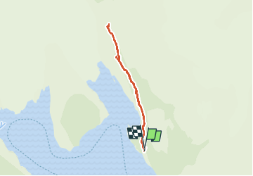
Trail Walking of 12.9 km to be discovered at Region of Magallanes and Chilean Antarctica, Provincia de Última Esperanza, Torres del Paine. This trail is proposed by GOHIER.

Description

Montée depuis Camp Grey à la troisième passerelle. Absolument sublime avec un temps magnifique.
Magique !

Elevation profile

Positioning

Country:
Chile
Region :
Region of Magallanes and Chilean Antarctica
Department/Province :
Provincia de Última Esperanza
Municipality :
Torres del Paine
Location:
Unknown
Start:(UTM)
627947 ; 4347720 (18F) S.

Trails nearby

Trail Motorboat Torres del Paine - Lago Grey - Photo
Motorboat
GOHIER

Motorboat

Very easy
Torres del Paine, Region of Magallanes and Chilean Antarctica, Provincia de Última Esperanza, Chile
34 km | 38 km-effort
3h 39min
No


Close
My subscriptions